Unsupervised Land Cover Classification App
Overview
A machine learning project applying unsupervised K-Means clustering to Landsat 8 satellite imagery to classify land cover across Malaybalay City, Bukidnon, Philippines — down to the barangay level. Built as a personal initiative to explore machine learning in the context of remote sensing, the app generates a 7-class land cover map and provides an interactive barangay-level insight panel with per-class area statistics and export capability.
Study Area: Malaybalay City, Bukidnon, Philippines — all barangays
Role: Solo project
Status: In Progress
Methods & Tools
Data Sources
- Landsat 8 Collection 2 Tier 1 Surface Reflectance (LANDSAT/LC08/C02/T1_L2) — multispectral satellite imagery via Google Earth Engine
- Custom barangay boundary asset — Malaybalay City barangay polygons uploaded as a personal GEE asset (
projects/ee-alexmaverickpabillaran/assets/MalaybalayCityBrgy)
Processing Steps
- Filtered Landsat 8 imagery over Malaybalay City for 2024–2025, limited to the dry season months (March–May) and scenes with less than 15% cloud cover
- Applied surface reflectance scaling factors and computed a median composite across all valid scenes
- Selected six spectral bands — Blue, Green, Red, NIR, SWIR1, SWIR2 — as input features for clustering
- Trained a K-Means clusterer (Weka K-Means, 7 clusters, seed = 42) on 5,000 randomly sampled pixels from the study area
- Applied the trained clusterer to the full composite image to generate a 7-class land cover map
- Computed per-class pixel area (km²) for any selected barangay or the whole city using
ee.Image.pixelArea() - Rendered results in an interactive side panel with barangay dropdown, area statistics, and export functionality
Tools Used
| Tool | Purpose |
|---|---|
| Google Earth Engine | Satellite imagery processing, K-Means clustering, area computation, and interactive map rendering |
| JavaScript (GEE Code Editor) | App scripting, UI panel and insight panel development |
| Claude AI | Code refinement, documentation, and project write-up |
Key Features
- 7-Class Land Cover Map — Classifies Malaybalay City into Built-up/Urban, Bare Soil/Exposed, Turbid/Shallow Water, Sparse Vegetation, Moderate Vegetation, Dense Vegetation, and Cloud/Shadow/Mixed
- Barangay-level Insight Panel — Select any barangay from a dropdown to zoom in, highlight its boundary, and view a ranked breakdown of land cover classes by area (km²) and percentage
- Whole-City View — Defaults to a city-wide analysis, then narrows to barangay level on selection
- Export Cluster Map — Queues a GeoTIFF export of the classified raster for any selected area to Google Drive via the GEE Tasks tab
- Satellite Basemap — Classification layer rendered on top of a satellite basemap for visual context
Sample Output — Barangay 1
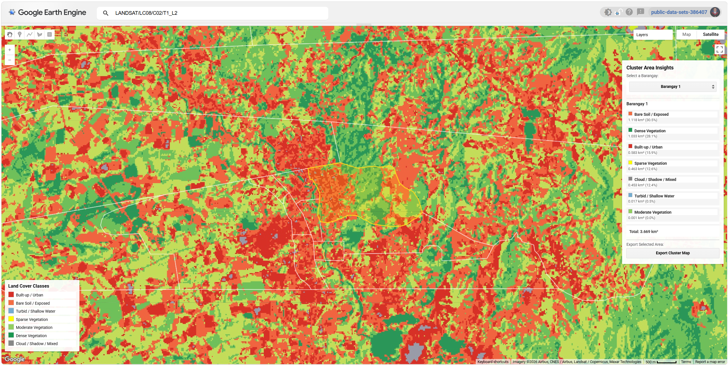
The screenshot above shows the app's output zoomed into Barangay 1, with the barangay boundary highlighted in gold. The insight panel on the right shows the area breakdown for that barangay.
| Class | Area | Share |
|---|---|---|
| Bare Soil / Exposed | 1.118 km² | 30.5% |
| Dense Vegetation | 1.033 km² | 28.1% |
| Built-up / Urban | 0.583 km² | 15.9% |
| Sparse Vegetation | 0.463 km² | 12.6% |
| Cloud / Shadow / Mixed | 0.453 km² | 12.4% |
| Turbid / Shallow Water | 0.017 km² | 0.5% |
| Moderate Vegetation | 0.001 km² | 0.0% |
| Total | 3.669 km² |
The map reveals a mix of bare soil and agricultural land dominating Barangay 1, with pockets of dense vegetation and scattered built-up areas. The high proportion of bare soil likely reflects dry-season field conditions captured during the March–May image window.
Land Cover Classes
| Color | Class |
|---|---|
| 🟥 Dark Red | Built-up / Urban |
| 🟧 Orange-Red | Bare Soil / Exposed |
| 🟦 Blue | Turbid / Shallow Water |
| 🟨 Yellow | Sparse Vegetation |
| 🟩 Light Green | Moderate Vegetation |
| 🟢 Dark Green | Dense Vegetation |
| ⬜ Grey | Cloud / Shadow / Mixed |
Source Code
// ============================================================
// Unsupervised Classification – Landsat 8 | 8-Class K-Means
// Malaybalay City, Bukidnon — Barangay Insight Panel
// ============================================================

// ── 0. ASSET ─────────────────────────────────────────────
var malaybalay = ee.FeatureCollection('projects/ee-alexmaverickpabillaran/assets/MalaybalayCityBrgy');
var cityBoundary = malaybalay.geometry().dissolve();

// ── 1. IMAGE ─────────────────────────────────────────────
var composite = ee.ImageCollection('LANDSAT/LC08/C02/T1_L2')
  .filterBounds(cityBoundary)
  .filterDate('2024-01-01', '2025-12-31')
  .filter(ee.Filter.calendarRange(3, 5, 'month'))
  .filter(ee.Filter.lt('CLOUD_COVER', 15))
  .map(function(image) {
    return image.select('SR_B.').multiply(0.0000275).add(-0.2);
  })
  .median()
  .select(
    ['SR_B2','SR_B3','SR_B4','SR_B5','SR_B6','SR_B7'],
    ['Blue','Green','Red','NIR','SWIR1','SWIR2']
  )
  .clip(cityBoundary);

// ── 2. CLUSTERING ────────────────────────────────────────
var NUM_CLUSTERS = 7;

var clusterer = ee.Clusterer.wekaKMeans({
  nClusters: NUM_CLUSTERS,
  seed: 42,
  fast: true
}).train(
  composite.sample({
    region: cityBoundary,
    scale: 30,
    numPixels: 5000,
    seed: 42,
    geometries: false
  })
);

var clustered = composite.cluster(clusterer);

// ── 3. CONFIG ────────────────────────────────────────────
var PALETTE = [
  '#d73027','#f46d43','#74add1','#ffff00',
  '#91cf60','#1a9850','#878787',
];

var LABELS = [
  'Built-up / Urban',
  'Bare Soil / Exposed',
  'Turbid / Shallow Water',
  'Sparse Vegetation',
  'Moderate Vegetation',
  'Dense Vegetation',
  'Cloud / Shadow / Mixed'
];

// ── 4. MAP ───────────────────────────────────────────────
Map.setOptions('SATELLITE');
Map.centerObject(cityBoundary, 11);

Map.addLayer(
  clustered,
  {min: 0, max: 7, palette: PALETTE},
  'Land Cover Clusters'
);

Map.addLayer(
  malaybalay.style({color: '#ffffff', fillColor: '00000000', width: 1}),
  {},
  'Barangay Boundaries'
);

Map.addLayer(ee.Image(0).selfMask(), {}, 'Selected Barangay', false);

// ── 5. LEGEND ────────────────────────────────────────────
var legend = ui.Panel({
  style: {
    position: 'bottom-left',
    padding: '10px',
    width: '210px',
    backgroundColor: 'rgba(255,255,255,0.93)'
  }
});

legend.add(ui.Label({
  value: 'Land Cover Classes',
  style: {fontWeight: 'bold', fontSize: '13px', margin: '0 0 6px 0'}
}));

LABELS.forEach(function(label, i) {
  var row = ui.Panel({
    layout: ui.Panel.Layout.flow('horizontal'),
    style: {margin: '2px 0'}
  });
  row.add(ui.Label({
    style: {
      backgroundColor: PALETTE[i],
      padding: '7px',
      margin: '0 6px 0 0',
      border: '1px solid #ccc'
    }
  }));
  row.add(ui.Label({
    value: label,
    style: {fontSize: '11px', margin: '3px 0'}
  }));
  legend.add(row);
});

Map.add(legend);

// ── 6. INSIGHT PANEL ─────────────────────────────────────
var insightPanel = ui.Panel({
  style: {
    position: 'top-right',
    padding: '12px',
    width: '285px',
    backgroundColor: 'rgba(255,255,255,0.96)'
  }
});

insightPanel.add(ui.Label({
  value: 'Cluster Area Insights',
  style: {fontWeight: 'bold', fontSize: '14px', margin: '0 0 4px 0'}
}));

insightPanel.add(ui.Label({
  value: 'Select a Barangay:',
  style: {fontSize: '11px', color: '#444', margin: '4px 0 2px 0'}
}));

var dropdownSlot = ui.Panel({
  style: {margin: '0 0 8px 0', stretch: 'horizontal'}
});
dropdownSlot.add(ui.Label({
  value: 'Loading barangays...',
  style: {fontSize: '11px', color: '#888'}
}));
insightPanel.add(dropdownSlot);

insightPanel.add(ui.Panel({
  style: {
    height: '1px',
    backgroundColor: '#ddd',
    margin: '2px 0 8px 0',
    stretch: 'horizontal'
  }
}));

var resultsContainer = ui.Panel({layout: ui.Panel.Layout.flow('vertical')});
insightPanel.add(resultsContainer);

// ── Export buttons ────────────────────────────────────────
insightPanel.add(ui.Panel({
  style: {
    height: '1px',
    backgroundColor: '#ddd',
    margin: '8px 0 6px 0',
    stretch: 'horizontal'
  }
}));

insightPanel.add(ui.Label({
  value: 'Export Selected Area:',
  style: {fontSize: '11px', color: '#444', margin: '0 0 4px 0'}
}));

var btnRow = ui.Panel({
  layout: ui.Panel.Layout.flow('horizontal'),
  style: {margin: '0'}
});

btnRow.add(ui.Button({
  label: 'Export Cluster Map',
  style: {fontSize: '11px', margin: '0', stretch: 'horizontal'},
  onClick: function() { exportLayer('cluster'); }
}));

insightPanel.add(btnRow);

var exportStatus = ui.Label({
  value: '',
  style: {fontSize: '10px', color: '#888', margin: '4px 0 0 0'}
});
insightPanel.add(exportStatus);

Map.add(insightPanel);

// ── 7. STATE ─────────────────────────────────────────────
var activeGeom = cityBoundary;
var activeName = 'WholeCity';

// ── 8. EXPORT ────────────────────────────────────────────
function exportLayer(type) {
  var safeName = activeName.replace(/[^a-zA-Z0-9]/g, '_');

  if (type === 'cluster') {
    Export.image.toDrive({
      image: clustered.clip(activeGeom).toByte(),
      description: 'ClusterMap_' + safeName,
      folder: 'GEE_Exports',
      fileNamePrefix: 'ClusterMap_' + safeName,
      scale: 30,
      region: activeGeom,
      maxPixels: 1e9,
      fileFormat: 'GeoTIFF'
    });
    exportStatus.setValue('✓ Cluster export queued — check Tasks tab');
  }
}

// ── 9. POPULATE DROPDOWN ─────────────────────────────────
malaybalay.aggregate_array('NAME_3').sort().evaluate(function(names) {
  var items = ['— Whole City —'].concat(names);

  var dropdown = ui.Select({
    items: items,
    value: '— Whole City —',
    style: {stretch: 'horizontal'},
    onChange: function(selected) {
      exportStatus.setValue('');

      Map.layers().set(2,
        ui.Map.Layer(ee.Image(0).selfMask(), {}, 'Selected Barangay', false)
      );

      if (selected === '— Whole City —') {
        activeGeom = cityBoundary;
        activeName = 'WholeCity';
        Map.centerObject(cityBoundary, 12);
        runAnalysis('— Whole City —');
      } else {
        var brgy = malaybalay.filter(ee.Filter.eq('NAME_3', selected));
        activeGeom = brgy.geometry();
        activeName = selected;
        Map.layers().set(2,
          ui.Map.Layer(
            brgy.style({color: '#FFD700', fillColor: 'FFD70033', width: 2}),
            {},
            'Selected: ' + selected
          )
        );
        Map.centerObject(brgy, 14);
        runAnalysis(selected);
      }
    }
  });

  dropdownSlot.clear();
  dropdownSlot.add(dropdown);
  runAnalysis('— Whole City —');
});

// ── 10. ANALYSIS ─────────────────────────────────────────
function runAnalysis(selected) {
  resultsContainer.clear();
  resultsContainer.add(ui.Label({
    value: 'Calculating...',
    style: {fontSize: '11px', color: '#888'}
  }));

  var geom = selected === '— Whole City —'
    ? cityBoundary
    : malaybalay.filter(ee.Filter.eq('NAME_3', selected)).geometry();

  var areaImage = ee.Image.pixelArea().divide(1e6);
  var areas = new Array(NUM_CLUSTERS);
  var done = 0;

  for (var i = 0; i < NUM_CLUSTERS; i++) {
    (function(idx) {
      areaImage
        .updateMask(clustered.eq(idx))
        .reduceRegion({
          reducer: ee.Reducer.sum(),
          geometry: geom,
          scale: 30,
          maxPixels: 1e9
        })
        .evaluate(function(val) {
          areas[idx] = (val && val.area) ? val.area : 0;
          done++;
          if (done === NUM_CLUSTERS) renderResults(areas, selected);
        });
    })(i);
  }
}

// ── 11. RENDER ───────────────────────────────────────────
function renderResults(areas, selected) {
  resultsContainer.clear();

  var total = areas.reduce(function(a, b) { return a + b; }, 0);

  resultsContainer.add(ui.Label({
    value: selected,
    style: {fontWeight: 'bold', fontSize: '12px', color: '#222', margin: '0 0 6px 0'}
  }));

  var sorted = areas
    .map(function(a, i) { return {idx: i, area: a}; })
    .sort(function(a, b) { return b.area - a.area; });

  sorted.forEach(function(item) {
    var pct = total > 0
      ? ((item.area / total) * 100).toFixed(1)
      : '0.0';

    var row = ui.Panel({
      layout: ui.Panel.Layout.flow('vertical'),
      style: {
        margin: '3px 0',
        padding: '5px',
        backgroundColor: '#f5f5f5',
        stretch: 'horizontal'
      }
    });

    var topRow = ui.Panel({layout: ui.Panel.Layout.flow('horizontal')});
    topRow.add(ui.Label({
      style: {
        backgroundColor: PALETTE[item.idx],
        padding: '5px',
        margin: '0 6px 0 0',
        border: '1px solid #bbb'
      }
    }));
    topRow.add(ui.Label({
      value: LABELS[item.idx],
      style: {fontSize: '11px', fontWeight: 'bold', color: '#222', margin: '2px 0'}
    }));
    row.add(topRow);

    row.add(ui.Label({
      value: '  ' + item.area.toFixed(3) + ' km²  (' + pct + '%)',
      style: {fontSize: '10px', color: '#555', margin: '1px 0 0 0'}
    }));

    resultsContainer.add(row);
  });

  resultsContainer.add(ui.Panel({
    style: {
      height: '1px',
      backgroundColor: '#ccc',
      margin: '6px 0 4px 0',
      stretch: 'horizontal'
    }
  }));

  resultsContainer.add(ui.Label({
    value: 'Total: ' + total.toFixed(3) + ' km²',
    style: {fontSize: '11px', fontWeight: 'bold', color: '#333'}
  }));
}
References
- USGS / NASA. Landsat 8 Collection 2 Tier 1 Surface Reflectance [Dataset]. Google Earth Engine. Retrieved from https://developers.google.com/earth-engine/datasets/catalog/LANDSAT_LC08_C02_T1_L2